Property Record
1909 Unknown, Grant, FL 32949

NEARBY LISTINGS FOR SALE OR LEASE
-
-
View all Grant listings for sale on LoopNet.com
Property Detail
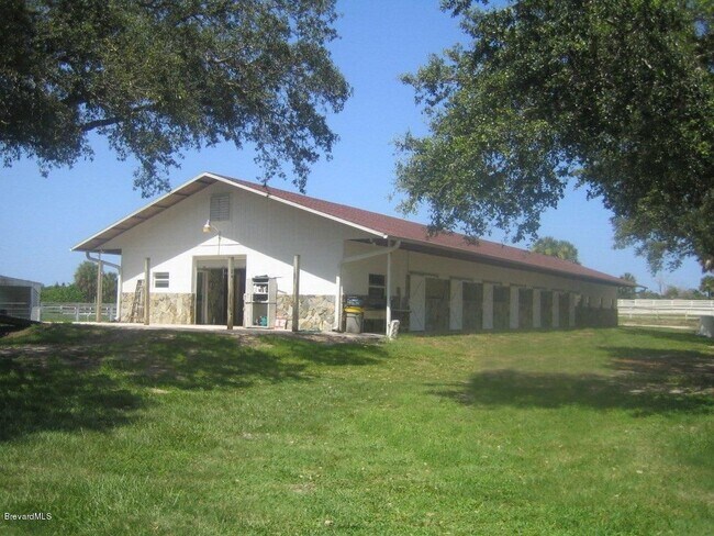
1909 Unknown
Palm Bay-Melbourne-Titusville, FL
Jorgensons Plat Of Grant
29-38-28-25-0000X.0-0009.02
JORGENSONS PLAT OF GRANT PART OT LOT 9 BLK X & PART OT LOT 13 BLK Y & VAC 6TH ST ALL LYING W OF TROUT CREEK DESC AS PARCEL A OF EXHIBIT B IN ORB 5657 PB 516
Agriculturalland
Brevard
AE
Florida
12009C0691G
9
2024
2.52 AC
2025
Brevard County
065231
Orlando
DEMOGRAPHICS near 1909 Unknown
1 mile
3 mile
5 mile
2024 Total Population
748
7,847
20,417
2029 Population
817
8,764
22,719
Pop Growth 2024-2029
+ 9.22%
+ 11.69%
+ 11.27%
Average Age
50
56
58
2024 Total Households
308
3,740
10,309
HH Growth 2024-2029
+ 9.09%
+ 11.47%
+ 11.06%
Median Household Inc
$99,341
$85,640
$56,760
Avg Household Size
2.40
2.10
2.00
2024 Avg HH Vehicles
2.00
2.00
2.00
Median Home Value
$419,231
$424,905
$328,242
Median Year Built
1994
1993
1988
Nearby Places
Map Layers
Map Styles
 Street
 Aerial
Transit
 Traffic
 Biking
Places
Listings with unknown addresses are not visible on the map
- Restaurants
- Banks
- Shops
- Fitness
- Groceries
PUBLIC TRANSPORTATION
AIRPORT
Melbourne Orlando International
Drive
Walk
Distance
Melbourne Orlando International
36 min
18.0 mi
Freight Ports
Port Canaveral
Drive
Walk
Distance
Port Canaveral
74 min
54.4 mi
SALE & LEASE HISTORY
LISTING DATE
SALE/LEASE

Dec 16, 2020
For Sale
Nearby Properties
Address
Land Use
TOTAL SIZE
Lot Size
Zoning
Address
Land Use
TOTAL SIZE
Lot Size
Zoning
161,823 SF
619.70 AC
GML
Address
Land Use
TOTAL SIZE
Lot Size
Zoning
10 AC
GML
Address
Land Use
TOTAL SIZE
Lot Size
Zoning
17,613 SF
1.15 AC
RR-1
Address
Land Use
TOTAL SIZE
Lot Size
Zoning
32.59 AC
EA
Address
Land Use
TOTAL SIZE
Lot Size
Zoning
372.56 AC
Address
Land Use
TOTAL SIZE
Lot Size
Zoning
1,668 SF
2.24 AC
RR1
Address
Land Use
TOTAL SIZE
Lot Size
Zoning
6,562 SF
0.57 AC
SR
Address
Land Use
TOTAL SIZE
Lot Size
Zoning
11,739 SF
0.90 AC
RU24
Address
Land Use
TOTAL SIZE
Lot Size
Zoning
5,527 SF
2.16 AC
SR
Address
Land Use
TOTAL SIZE
Lot Size
Zoning
18,612 SF
67.22 AC
PA
Address
Land Use
TOTAL SIZE
Lot Size
Zoning
8,094 SF
0.83 AC
SR
Address
Land Use
TOTAL SIZE
Lot Size
Zoning
8,121 SF
1.10 AC
RU24
Address
Land Use
TOTAL SIZE
Lot Size
Zoning
8,760 SF
0.82 AC
SR
Address
Land Use
TOTAL SIZE
Lot Size
Zoning
27.34 AC
GML
Address
Land Use
TOTAL SIZE
Lot Size
Zoning
4,447 SF
0.87 AC
SR
Address
Land Use
TOTAL SIZE
Lot Size
Zoning
7,470 SF
0.82 AC
SR
Address
Land Use
TOTAL SIZE
Lot Size
Zoning
2.31 AC
GML
Address
Land Use
TOTAL SIZE
Lot Size
Zoning
6,106 SF
1.36 AC
RU24
Address
Land Use
TOTAL SIZE
Lot Size
Zoning
6,683 SF
0.39 AC
RU113
Address
Land Use
TOTAL SIZE
Lot Size
Zoning
2,313 SF
7.33 AC
GML
Address
Land Use
TOTAL SIZE
Lot Size
Zoning
7,912 SF
0.68 AC
RU19
Address
Land Use
TOTAL SIZE
Lot Size
Zoning
1.14 AC
SR
Address
Land Use
TOTAL SIZE
Lot Size
Zoning
5,372 SF
0.55 AC
RU-1-13
Address
Land Use
TOTAL SIZE
Lot Size
Zoning
9,314 SF
0.38 AC
RU113
Address
Land Use
TOTAL SIZE
Lot Size
Zoning
15.95 AC
RU-1-13
Address
Land Use
TOTAL SIZE
Lot Size
Zoning
7,804 SF
0.68 AC
RU19
Address
Land Use
TOTAL SIZE
Lot Size
Zoning
5,171 SF
0.82 AC
SR
Address
Land Use
TOTAL SIZE
Lot Size
Zoning
4,941 SF
0.55 AC
RU113
Address
Land Use
TOTAL SIZE
Lot Size
Zoning
5,904 SF
0.56 AC
SR
Address
Land Use
TOTAL SIZE
Lot Size
Zoning
1.19 AC
RU24
The World's #1 Commercial Real Estate Marketplace
Connect with us
© 2026 CoStar Group
The information above has been obtained from sources believed reliable. While we do not doubt its accuracy we have not verified it and make no guarantee, warranty or representation about it. It is your responsibility to independently confirm its accuracy and completeness. Any projections, opinions, assumptions, or estimates used are for example only and do not represent the current or future performance of the property. The value of this transaction to you depends on tax and other factors which should be evaluated by your tax, financial, and legal advisors. You and your advisors should conduct a careful, independent investigation of the property to determine to your satisfaction the suitability of the property for your needs.